


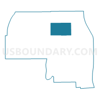
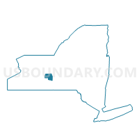
Voting District 020002, Yates County, New York
About
Outline

Summary
| Unique Area Identifier | 639201 |
| Name | Voting District 020002 |
| County | Yates County |
| State | New York |
| Area (square miles) | 18.07 |
| Land Area (square miles) | 18.07 |
| Water Area (square miles) | 0.00 |
| % of Land Area | 100.00 |
| % of Water Area | 0.00 |
| Latitude of the Internal Point | 42.69346850 |
| Longtitude of the Internal Point | -77.06909270 |
Maps

Graphs
Select a template below for downloading or customizing gragh for Voting District 020002, Yates County, New York


Neighbors
Neighoring Voting District (by Name) Neighboring Voting District on the Map
- Voting District 020001, Yates County, NY
- Voting District 040004, Yates County, NY
- Voting District 060001, Yates County, NY
- Voting District 060002, Yates County, NY
- Voting District 060003, Yates County, NY
- Voting District 060006, Yates County, NY
- Voting District 070002, Yates County, NY
- Voting District 090001, Yates County, NY
Top 10 Neighboring County Subdivision (by Population) Neighboring County Subdivision on the Map
- Milo town, Yates County, NY (7,006)
- Jerusalem town, Yates County, NY (4,469)
- Benton town, Yates County, NY (2,836)
- Potter town, Yates County, NY (1,865)
- Torrey town, Yates County, NY (1,282)